swindonweb®  home    make this my homepage
myswindonweb   LOGIN / REGISTER  

Maps of Swindon 

Where is Swindon?
 
Swindon is the largest town in the county of Wiltshire, in the south of England. It is situated 81 miles (130 km) west of London and 39 miles (63 km) east of Bristol. It is 29 miles (47 km) south-west of Oxford and 76 miles (122 km) south of Birmingham.

It is close to the M4 motorway: junction 15 serving the east and junction 16 serving the west of the town. Swindon is also still a railway junction, situated on the main London-Bristol line where it branches to Gloucester and Cheltenham.
 
Swindon Map
 
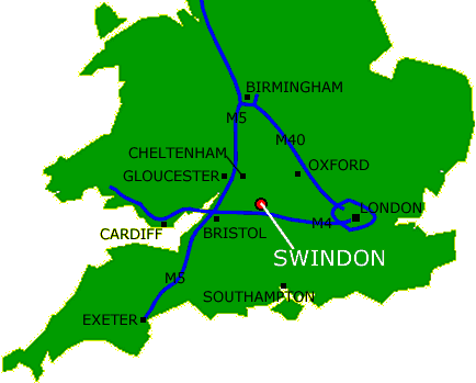
While we generate a fully interactive map of Swindon, here some links to key sites in and around town using multimap.
 
Show me a map of how to find....
 
Map logo  Arts Centre
Map logo  Bus Station
Map logo  Citizen's Advice Bureau
Map logo  Designer Outlet Village
Map logo  Honda factory
Map logo  Library (main)
Map logo  Magistrates Court
Map logo  Motorola factory
Map logo  Police Station HQ
Map logo  Park & Ride (North Swindon)
 Park & Ride (South Swindon)
Map logo
 STEAM museum
Map logo  Swindon Town Football Club
Map logo  Train station
Map logo  Walmart (Asda)
Map logo  Wyvern Theatre
myswindonweb
Absolute Skips - skip hire in Swindon
The Burj
Deacons
Barnes Coaches Advert
Chelworth Windows and Conservatories, Swindon, Wiltshire
Toomers